
Thank you for supporting this site ❤️
Make a donation
Make a donation
Gear up for your next adventure:
As an Amazon Associate, this site earns from qualifying purchases at no extra cost to you.
Montalvo topographic map
Click on the map to display elevation.
Thank you for supporting this site ❤️
Make a donation
Make a donation
Gear up for your next adventure:
As an Amazon Associate, this site earns from qualifying purchases at no extra cost to you.
About this map
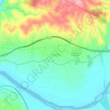
Name: Montalvo topographic map, elevation, terrain.
Location: Montalvo, Constância, Santarém, Portugal (39.46239 -8.31604 39.50700 -8.27246)
Average elevation: 83 m
Minimum elevation: 11 m
Maximum elevation: 230 m
Thank you for supporting this site ❤️
Make a donation
Make a donation
Gear up for your next adventure:
As an Amazon Associate, this site earns from qualifying purchases at no extra cost to you.
Other topographic maps
Click on a map to view its topography, its elevation and its terrain.
Parque Ambiental de Santa Margarida
Portugal > Santarém > Constância > Santa Margarida da Coutada
Average elevation: 109 m