Geolocate

Saint-Quentin topographic map

Click on the map to display elevation.

About this map
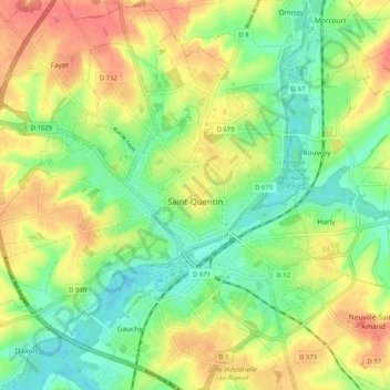
Name: Saint-Quentin topographic map, elevation, terrain.

Location: Saint-Quentin, Aisne, Hauts-de-France, Metropolitan France, 02100, France (49.82017 3.22810 49.87486 3.32989)

Average elevation: 96 m

Minimum elevation: 66 m

Maximum elevation: 134 m

Other topographic maps

Click on a map to view its topography, its elevation and its terrain.

Les Hézettes

France > Hauts-de-France > Aisne > Guivry

Average elevation: 111 m

Coutenval

France > Hauts-de-France > Aisne > Jeantes

Average elevation: 201 m

Montcourt

France > Hauts-de-France > Aisne > Essômes-sur-Marne

Average elevation: 133 m

Le Bac

France > Hauts-de-France > Aisne > Bichancourt

Average elevation: 49 m

Reddy

France > Hauts-de-France > Aisne > Coulonges-Cohan

Average elevation: 190 m

Buirefontaine

France > Hauts-de-France > Aisne > Aubenton

Average elevation: 198 m

Les Hausseaux

France > Hauts-de-France > Aisne > Any-Martin-Rieux

Average elevation: 214 m

La Rue Charles

France > Hauts-de-France > Aisne > Besmont

Average elevation: 204 m

Gear up for your next adventure:

🍽️Titanium Camping Spork - Ultralight and indestructible eating utensil
🥾Hiking Shorts - Breathable shorts suitable for summer hikes
🥾Waterproof Hiking Boots - Boots keeping your feet dry in wet conditions
🧥Waterproof Pants - Keep dry during rainy hiking conditions
🚲MTB Frame Bag - Carry tools and maps directly on your bicycle frame

As an Amazon Associate, this site earns from qualifying purchases at no extra cost to you.