Geolocate

Balung topographic map

Click on the map to display elevation.

About this map

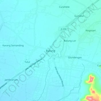
Name: Balung topographic map, elevation, terrain.

Location: Balung, Jember, East Java, Java, 68161, Indonesia (-8.31575 113.49730 -8.23575 113.57730)

Average elevation: 29 m

Minimum elevation: 12 m

Maximum elevation: 240 m

Gear up for your next adventure:

🧭GPS Handheld Device - Reliable GPS navigation for outdoor adventures
Backpacking Tent - Lightweight tent for long-distance hiking trips
🚑Survival Whistle - Signal for help across long distances in mountains
🥾Approach Shoes - Shoes designed for climbing approaches and rugged trails
🥾Hiking Boots - Sturdy boots providing ankle support and traction on rugged trails

As an Amazon Associate, this site earns from qualifying purchases at no extra cost to you.