
Thank you for supporting this site ❤️
Make a donation
Make a donation
Gear up for your next adventure:
As an Amazon Associate, this site earns from qualifying purchases at no extra cost to you.
Piaghe/Ploaghe topographic map
Click on the map to display elevation.
Thank you for supporting this site ❤️
Make a donation
Make a donation
Gear up for your next adventure:
As an Amazon Associate, this site earns from qualifying purchases at no extra cost to you.
About this map
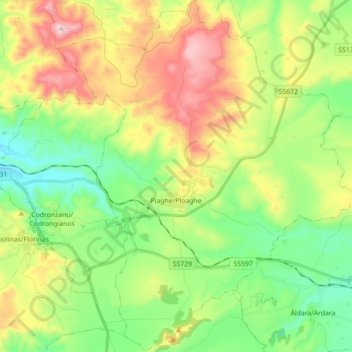
Name: Piaghe/Ploaghe topographic map, elevation, terrain.
Location: Piaghe/Ploaghe, Sassari, Sardinia, 07017, Italy (40.60683 8.68262 40.74021 8.83330)
Average elevation: 390 m
Minimum elevation: 172 m
Maximum elevation: 758 m
Thank you for supporting this site ❤️
Make a donation
Make a donation
Gear up for your next adventure:
As an Amazon Associate, this site earns from qualifying purchases at no extra cost to you.
Other topographic maps
Click on a map to view its topography, its elevation and its terrain.