Geolocate

Bonbon topographic map

Click on the map to display elevation.

About this map

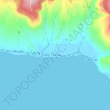
Name: Bonbon topographic map, elevation, terrain.

Location: Bonbon, Sagay, Camiguin, Northern Mindanao, 9103, Philippines (9.08377 124.71214 9.12377 124.75214)

Average elevation: 43 m

Minimum elevation: -1 m

Maximum elevation: 264 m

Other topographic maps

Click on a map to view its topography, its elevation and its terrain.

Sagay Park

Philippines > Camiguin > Sagay > Mayana

Average elevation: 27 m

Gear up for your next adventure:

🥾Hiking Shorts - Breathable shorts suitable for summer hikes
🥘Camping Cookware Set - Compact nesting pots and pans for trail cooking
🧦Merino Wool Socks - Moisture-wicking comfort for long-distance hiking
🧥Waterproof Hiking Jacket - Protect yourself from rain and wind while hiking
🦶Anti-Blister Balm - Prevents friction and hotspots during long ascents

As an Amazon Associate, this site earns from qualifying purchases at no extra cost to you.