
Kaniv topographic map
Interactive map
Click on the map to display elevation.
About this map
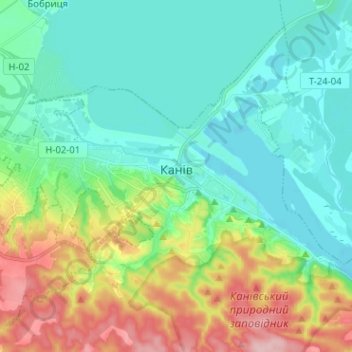
Name: Kaniv topographic map, elevation, terrain.
Location: Kaniv, Oblast de Tcherkassy, 19000-19009, Ukraine (49.72332 31.39203 49.78398 31.51932)
Average elevation: 126 m
Minimum elevation: 77 m
Maximum elevation: 250 m
Other topographic maps
Click on a map to view its topography, its elevation and its terrain.
Kaniv
Ukraine > Oblast de Tcherkassy > Kaniv
Kaniv, Черкаський район, Oblast de Tcherkassy, 19000-19009, Ukraine
Average elevation: 123 m