
Make a donation
Gear up for your next adventure:
As an Amazon Associate, this site earns from qualifying purchases at no extra cost to you.
Dardhë topographic map
Click on the map to display elevation.
Make a donation
Gear up for your next adventure:
As an Amazon Associate, this site earns from qualifying purchases at no extra cost to you.
About this map
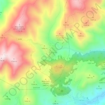
Name: Dardhë topographic map, elevation, terrain.
Location: Dardhë, Drenovë, Bashkia Korçë, Korçë County, 7023, Albania (40.49878 20.80737 40.53878 20.84737)
Average elevation: 1,383 m
Minimum elevation: 1,068 m
Maximum elevation: 1,718 m
Make a donation
Gear up for your next adventure:
As an Amazon Associate, this site earns from qualifying purchases at no extra cost to you.
Other topographic maps
Click on a map to view its topography, its elevation and its terrain.
Voskopojë
The forms Voskopolis/Voskopoja derive from the Greek word Vosko (shepherd) which refers to one of the main professions performed by the Aromanian people. Also the suffix poja/polis from the syntagm can be either linked to the Greek word polis (city, citadel) or the Slavic polje, i.e. plain. Peyfuss strongly…
Average elevation: 1,270 m