Geolocate

Batiano topographic map

Click on the map to display elevation.

About this map

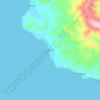
Name: Batiano topographic map, elevation, terrain.

Location: Batiano, Mati, Davao Oriental, Davao Region, 8200, Philippines (6.79445 126.27854 6.83445 126.31854)

Average elevation: 64 m

Minimum elevation: -1 m

Maximum elevation: 444 m

Other topographic maps

Click on a map to view its topography, its elevation and its terrain.

Mayo River

Philippines > Davao Oriental > Mati

Average elevation: 461 m

Gear up for your next adventure:

🌡️Emergency Mylar Blankets - Compact thermal protection for unexpected nights outdoors
🧭Orienteering Kit - Tools for map reading and navigation in the wild
🧢Beanie Hat - Keep your head warm in cold weather
Camping Tent - Weather-resistant tents suitable for 2 to 6 people
🧴Bear Spray Holster - Quick-access carry for essential Canadian wilderness safety

As an Amazon Associate, this site earns from qualifying purchases at no extra cost to you.