
Thank you for supporting this site ❤️
Make a donation
Make a donation
Gear up for your next adventure:
As an Amazon Associate, this site earns from qualifying purchases at no extra cost to you.
Aeroporto topographic map
Click on the map to display elevation.
Thank you for supporting this site ❤️
Make a donation
Make a donation
Gear up for your next adventure:
As an Amazon Associate, this site earns from qualifying purchases at no extra cost to you.
About this map
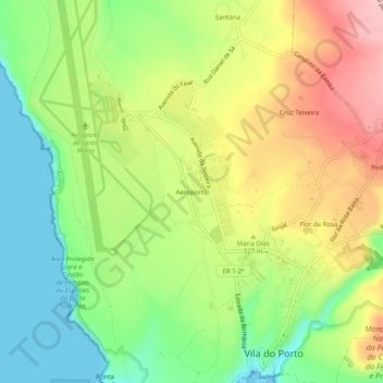
Name: Aeroporto topographic map, elevation, terrain.
Location: Aeroporto, Vila do Porto, Azores, 9580-408, Portugal (36.94495 -25.17612 36.98495 -25.13612)
Average elevation: 91 m
Minimum elevation: 0 m
Maximum elevation: 207 m
Thank you for supporting this site ❤️
Make a donation
Make a donation
Gear up for your next adventure:
As an Amazon Associate, this site earns from qualifying purchases at no extra cost to you.