
Municipal Unit of Sparta topographic map
Interactive map
Click on the map to display elevation.
About this map
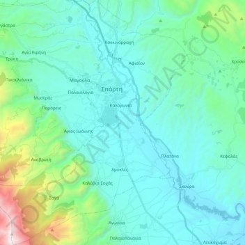
Name: Municipal Unit of Sparta topographic map, elevation, terrain.
Average elevation: 450 m
Minimum elevation: 113 m
Maximum elevation: 2,206 m
Other topographic maps
Click on a map to view its topography, its elevation and its terrain.
Sparta
Greece > Peloponnese, Western Greece and the Ionian > Laconia Regional Unit > Χαρίσιο
Sparta, Πλατανιστά, Χαρίσιο, Municipality of Sparta, Laconia Regional Unit, Peloponnese Region, Peloponnese, Western Greece and the Ionian, 23100, Greece
Average elevation: 214 m