
Udora topographic map
Interactive map
Click on the map to display elevation.
About this map
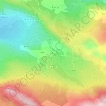
Name: Udora topographic map, elevation, terrain.
Average elevation: 314 m
Minimum elevation: 124 m
Maximum elevation: 547 m
Other topographic maps
Click on a map to view its topography, its elevation and its terrain.
Stolac
Bosnia and Herzegovina > Federation of Bosnia and Herzegovina > Town of Stolac
Stolac, Town of Stolac, Herzegovina-Neretva Canton, Federation of Bosnia and Herzegovina, 88360, Bosnia and Herzegovina
Average elevation: 290 m