Geolocate

Manildra topographic map

Click on the map to display elevation.

About this map

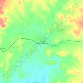
Name: Manildra topographic map, elevation, terrain.

Location: Manildra, Cabonne Council, New South Wales, Australia (-33.22459 148.65296 -33.14459 148.73296)

Average elevation: 463 m

Minimum elevation: 377 m

Maximum elevation: 635 m

Gear up for your next adventure:

🥾Waterproof Hiking Shoes - Durable shoes for wet and rugged trails
Backpacking Tent - Lightweight tent for long-distance hiking trips
🧭GPS Tracker - Track your location in remote areas safely
🛶Canoe Life Vest - Safety vest for water sports
🥾Mountain Hiking Shoes - Shoes with superior grip for mountainous terrain

As an Amazon Associate, this site earns from qualifying purchases at no extra cost to you.