
Teram Kangri I topographic map
Interactive map
Click on the map to display elevation.
About this map
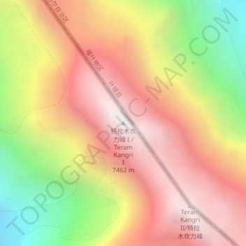
Name: Teram Kangri I topographic map, elevation, terrain.
Location: Teram Kangri I, Leh District, Jammu and Kashmir, India (35.58005 77.07849 35.58015 77.07859)
Average elevation: 6,620 m
Minimum elevation: 5,543 m
Maximum elevation: 7,425 m
Other topographic maps
Click on a map to view its topography, its elevation and its terrain.
Srinagar
India > Jammu and Kashmir > Srinagar
Srinagar, Srinagar (South), Srinagar District, Jammu and Kashmir, 190008, India
Average elevation: 1,805 m
Saser Kangri II
Saser Kangri II, Leh District, Jammu and Kashmir, India
Average elevation: 6,506 m