Geolocate

dongru topographic map

Click on the map to display elevation.

About this map

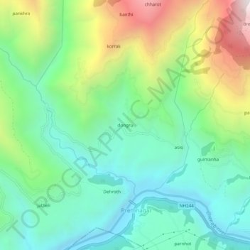
Name: dongru topographic map, elevation, terrain.

Location: dongru, Doda, Doda District, Jammu and Kashmir, India (33.15251 75.66542 33.19251 75.70542)

Average elevation: 1,326 m

Minimum elevation: 875 m

Maximum elevation: 2,294 m

Gear up for your next adventure:

Lightweight Camping Tent - Portable shelter optimized for Canadian backcountry camping
💡Portable Camping Lamp - Rechargeable lamp for campsite lighting
🔋Solar Power Bank - Keep your GPS and devices charged during long outdoor trips
🧊Insulated Water Bottle - Keeps drinks cold in summer and prevents freezing in winter
🕶️Polarized Sunglasses - Reduces glare from snow and water at high elevations

As an Amazon Associate, this site earns from qualifying purchases at no extra cost to you.