
Make a donation
Gear up for your next adventure:
As an Amazon Associate, this site earns from qualifying purchases at no extra cost to you.
Gargallo topographic map
Click on the map to display elevation.
Make a donation
Gear up for your next adventure:
As an Amazon Associate, this site earns from qualifying purchases at no extra cost to you.
Gargallo
Gargallo liegt etwa 70 Kilometer (Luftlinie) in nordnordöstlicher Richtung von der Provinzhauptstadt Teruel und etwa 89 Kilometer (Luftlinie) südsüdöstlich von Saragossa in einer Höhe von ca. 940 m.
Make a donation
Gear up for your next adventure:
As an Amazon Associate, this site earns from qualifying purchases at no extra cost to you.
About this map
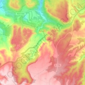
Name: Gargallo topographic map, elevation, terrain.
Location: Gargallo, Andorra-Sierra de Arcos, Teruel, Aragonien, Spanien (40.79142 -0.61869 40.86133 -0.54613)
Average elevation: 1,012 m
Minimum elevation: 797 m
Maximum elevation: 1,161 m
Make a donation
Gear up for your next adventure:
As an Amazon Associate, this site earns from qualifying purchases at no extra cost to you.