
Make a donation
Gear up for your next adventure:
As an Amazon Associate, this site earns from qualifying purchases at no extra cost to you.
Irig Municipality topographic map
Click on the map to display elevation.
Make a donation
Gear up for your next adventure:
As an Amazon Associate, this site earns from qualifying purchases at no extra cost to you.
About this map
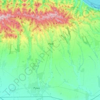
Name: Irig Municipality topographic map, elevation, terrain.
Average elevation: 192 m
Minimum elevation: 71 m
Maximum elevation: 533 m
Make a donation
Gear up for your next adventure:
As an Amazon Associate, this site earns from qualifying purchases at no extra cost to you.
Other topographic maps
Click on a map to view its topography, its elevation and its terrain.
Indjija
Serbia > Vojvodina > Srem Administrative District > Indjija Municipality
Average elevation: 110 m
Цигански логор
Serbia > Vojvodina > Srem Administrative District > Lezimir > Багрењак
Average elevation: 309 m
Maradik
Serbia > Vojvodina > Srem Administrative District > Indjija Municipality
Average elevation: 157 m
Stara Pazova
Serbia > Vojvodina > Srem Administrative District > Stara Pazova Municipality
Average elevation: 83 m
Make a donation
Gear up for your next adventure:
As an Amazon Associate, this site earns from qualifying purchases at no extra cost to you.
Beska
Serbia > Vojvodina > Srem Administrative District > Indjija Municipality
Average elevation: 128 m
Брдеж до
Serbia > Vojvodina > Srem Administrative District > Indjija Municipality > Cortanovci
Average elevation: 215 m
Krnjesevci
Serbia > Vojvodina > Srem Administrative District > Stara Pazova Municipality
Average elevation: 76 m
Make a donation
Gear up for your next adventure:
As an Amazon Associate, this site earns from qualifying purchases at no extra cost to you.