
Lagunillas topographic map
Interactive map
Click on the map to display elevation.
About this map
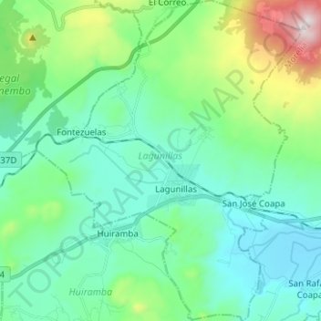
Name: Lagunillas topographic map, elevation, terrain.
Location: Lagunillas, Michoacán de Ocampo, México (19.51466 -101.47029 19.63216 -101.36716)
Average elevation: 2,241 m
Minimum elevation: 2,012 m
Maximum elevation: 3,069 m
Other topographic maps
Click on a map to view its topography, its elevation and its terrain.
Catedral asuncion
México > Michoacán de Ocampo > Apatzingán > Apatzingán
Catedral asuncion, Apatzingán, Michoacán de Ocampo, 60600, México
Average elevation: 329 m
Tancítaro
Tancítaro, Michoacán de Ocampo, México
Average elevation: 1,761 m
San Miguel del Monte
México > Michoacán de Ocampo > San Miguel del Monte
San Miguel del Monte, Morelia, Michoacán de Ocampo, México
Average elevation: 2,227 m