Geolocate

Al Mar topographic map

Click on the map to display elevation.

About this map
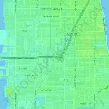
Name: Al Mar topographic map, elevation, terrain.

Location: Al Mar, Tampa, Hillsborough County, Florida, 33611, United States (27.87470 -82.53061 27.91470 -82.49061)

Average elevation: 8 m

Minimum elevation: -1 m

Maximum elevation: 18 m

Other topographic maps

Click on a map to view its topography, its elevation and its terrain.
Gear up for your next adventure:

🧦Crew Hiking Socks - Comfortable socks for long-distance hikes
🛏️Sleeping Bag - Warm and compact sleeping bags for outdoor camping
🧶550 Survival Paracord - Versatile utility cord for emergency repairs and rigging
🕶️Polarized Sunglasses - Protect your eyes with durable polarized lenses
🔭Outdoor Binoculars - Lightweight binoculars for birdwatching and hiking

As an Amazon Associate, this site earns from qualifying purchases at no extra cost to you.