Geolocate

Lancy topographic map

Click on the map to display elevation.

About this map

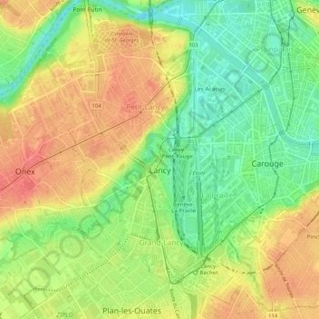
Name: Lancy topographic map, elevation, terrain.

Location: Lancy, Geneva, 1212, Switzerland (46.16735 6.10282 46.20282 6.14037)

Average elevation: 402 m

Minimum elevation: 367 m

Maximum elevation: 436 m

Other topographic maps

Click on a map to view its topography, its elevation and its terrain.

Vésenaz

Switzerland > Geneva

Average elevation: 412 m

Gear up for your next adventure:

💧Hydration Pack - Hands-free hydration system for long hikes
Camping Tent - Weather-resistant tents suitable for 2 to 6 people
🔋Emergency Crank Radio - Weather alerts and power without needing batteries
🥾Hiking Boots - Sturdy boots providing ankle support and traction on rugged trails
🥾Trail Hiking Shoes - Durable shoes designed for rugged trails

As an Amazon Associate, this site earns from qualifying purchases at no extra cost to you.