Geolocate

Ocopa topographic map

Click on the map to display elevation.

About this map

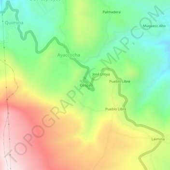
Name: Ocopa topographic map, elevation, terrain.

Location: Ocopa, Ayaccocha, Acoria, Huancavelica, Perú (-12.66722 -74.93684 -12.62722 -74.89684)

Average elevation: 3,978 m

Minimum elevation: 3,657 m

Maximum elevation: 4,398 m

Gear up for your next adventure:

🧭Orienteering Kit - Tools for map reading and navigation in the wild
🛏️Sleeping Bag - Warm and compact sleeping bags for outdoor camping
🧦Hiking Socks - Moisture-wicking and comfortable socks for long hikes
🥾Hiking Leggings - Comfortable leggings for outdoor activities
🎒Hiking Daypack - Lightweight and durable backpacks for day trips and excursions

As an Amazon Associate, this site earns from qualifying purchases at no extra cost to you.