Geolocate

Collepasso topographic map

Click on the map to display elevation.

About this map

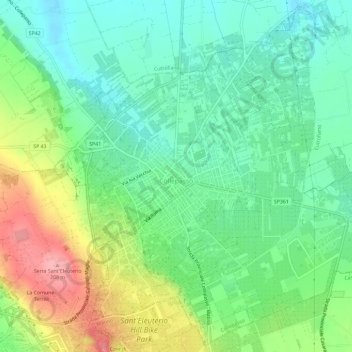
Name: Collepasso topographic map, elevation, terrain.

Location: Collepasso, Lecce, Apulia, Italy (40.05194 18.14268 40.09526 18.20114)

Average elevation: 130 m

Minimum elevation: 92 m

Maximum elevation: 200 m

Other topographic maps

Click on a map to view its topography, its elevation and its terrain.

Porto Miggiano

Italy > Apulia > Lecce > Santa Cesarea Terme

Average elevation: 48 m

Torre Rinalda

Italy > Apulia > Lecce > Lecce

Average elevation: 1 m

Santa Maria di Leuca

Italy > Apulia > Lecce

Average elevation: 41 m

Giorgilorio

Italy > Apulia > Lecce > Surbo > Giorgilorio

Average elevation: 43 m

Porto Badisco

Italy > Apulia > Lecce > Otranto

Average elevation: 38 m

Gear up for your next adventure:

🥾Mountain Hiking Boots - High-traction boots for rocky terrain
🥾Waterproof Hiking Shoes - Durable shoes for wet and rugged trails
🧴Insect Repellent - Protect yourself from bugs during outdoor adventures
🧢Hiking Sun Hat - Wide-brimmed protection for exposed mountain ridges
🧴Sunscreen SPF - Broad-spectrum sunscreen for outdoor activities

As an Amazon Associate, this site earns from qualifying purchases at no extra cost to you.