
Make a donation
Gear up for your next adventure:
As an Amazon Associate, this site earns from qualifying purchases at no extra cost to you.
Alexandria topographic map
Click on the map to display elevation.
Make a donation
Gear up for your next adventure:
As an Amazon Associate, this site earns from qualifying purchases at no extra cost to you.
Alexandria
Alexandria is located at 31°17′34″N 92°27′33″W / 31.29278°N 92.45917°W / 31.29278; -92.45917 and has an elevation of 75 feet (22.9 m).
Make a donation
Gear up for your next adventure:
As an Amazon Associate, this site earns from qualifying purchases at no extra cost to you.
About this map
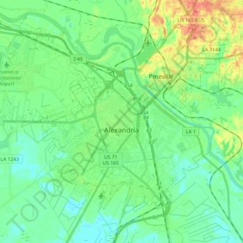
Name: Alexandria topographic map, elevation, terrain.
Location: Alexandria, Rapides Parish, Louisiana, United States (31.23155 -92.56580 31.35963 -92.39830)
Average elevation: 26 m
Minimum elevation: 11 m
Maximum elevation: 58 m
Make a donation
Gear up for your next adventure:
As an Amazon Associate, this site earns from qualifying purchases at no extra cost to you.
Other topographic maps
Click on a map to view its topography, its elevation and its terrain.
Alexandria
United States > Louisiana > Rapides Parish > Alexandria
Alexandria is located at 31°17′34″N 92°27′33″W / 31.29278°N 92.45917°W / 31.29278; -92.45917 and has an elevation of 75 feet (22.9 m).
Average elevation: 32 m