
Bathurst topographic map
Interactive map
Click on the map to display elevation.
About this map
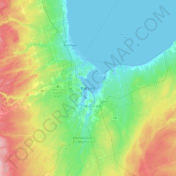
Name: Bathurst topographic map, elevation, terrain.
Location: Bathurst, City of Bathurst, New Brunswick, E2A0C4, Canada (47.46653 -65.81430 47.78653 -65.49430)
Average elevation: 66 m
Minimum elevation: -5 m
Maximum elevation: 230 m
Other topographic maps
Click on a map to view its topography, its elevation and its terrain.
Bathurst
Canada > New Brunswick > Bathurst
Bathurst, City of Bathurst, Gloucester County, New Brunswick, Canada
Average elevation: 26 m
Bass River
Canada > New Brunswick > Bathurst
Bass River, Bathurst, Bathurst Parish, Gloucester County, New Brunswick, Canada
Average elevation: 69 m