Geolocate

Omori topographic map

Click on the map to display elevation.

About this map

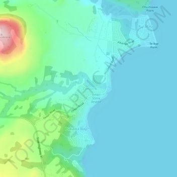
Name: Omori topographic map, elevation, terrain.

Location: Omori, Taupō District, Waikato, 3381, New Zealand (-38.92471 175.73521 -38.88471 175.77521)

Average elevation: 420 m

Minimum elevation: 350 m

Maximum elevation: 737 m

Other topographic maps

Click on a map to view its topography, its elevation and its terrain.

Hauhungaroa Range

New Zealand > Waikato > Taupo District

Average elevation: 753 m

Tongariro River

New Zealand > Waikato > Taupo District

Average elevation: 853 m

Lake Rotoaira

New Zealand > Waikato > Taupo District

Average elevation: 624 m

Lake Rotokawa

New Zealand > Waikato > Taupo District

Average elevation: 358 m

Lake Rotopounamu

New Zealand > Waikato > Taupo District

Average elevation: 784 m

Summit Plateau

New Zealand > Waikato > Taupo District

Average elevation: 2,454 m

Motutaiko Island

New Zealand > Waikato > Taupo District

Average elevation: 357 m

Gear up for your next adventure:

🔭Outdoor Binoculars - Lightweight binoculars for birdwatching and hiking
🥾Hiking Shoes - Durable and comfortable shoes for trail hiking
🥾All-Terrain Hiking Boots - Versatile boots for varied hiking conditions
Lightweight Camping Tent - Portable shelter optimized for Canadian backcountry camping
🦟Insect Repellent - Keep mosquitoes and black flies away in wooded areas

As an Amazon Associate, this site earns from qualifying purchases at no extra cost to you.