
Leeland topographic map
Click on the map to display elevation.
About this map
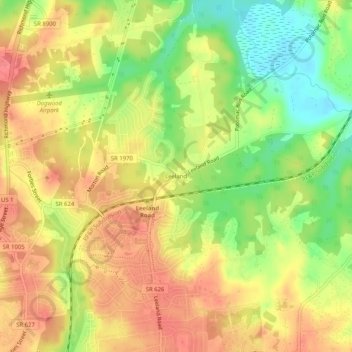
Name: Leeland topographic map, elevation, terrain.
Location: Leeland, Stafford County, Virginia, 22405, United States (38.32985 -77.45359 38.36985 -77.41359)
Average elevation: 42 m
Minimum elevation: 2 m
Maximum elevation: 71 m
Other topographic maps
Click on a map to view its topography, its elevation and its terrain.
Boswell's Corner
United States > Virginia > Stafford County > Boswell's Corner
Average elevation: 47 m
Southern Gateway
United States > Virginia > Stafford County > Southern Gateway
Average elevation: 73 m