
Make a donation
Gear up for your next adventure:
As an Amazon Associate, this site earns from qualifying purchases at no extra cost to you.
Westmalle topographic map
Click on the map to display elevation.
Make a donation
Gear up for your next adventure:
As an Amazon Associate, this site earns from qualifying purchases at no extra cost to you.
Westmalle
Westmalle ligt op een hoogte van 18-29 meter in de zandige Voorkempen. Bossen vindt men vooral ten westen van Westmalle en ten noordoosten van de plaats, bij het kasteel. De Brechtse Heide vindt men ten noordwesten van Westmalle.
Make a donation
Gear up for your next adventure:
As an Amazon Associate, this site earns from qualifying purchases at no extra cost to you.
About this map
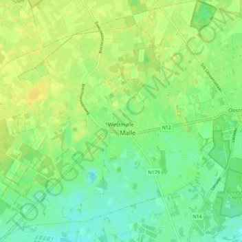
Name: Westmalle topographic map, elevation, terrain.
Location: Westmalle, Malle, Antwerpen, Vlaanderen, 2390, België (51.27250 4.63369 51.32684 4.71813)
Average elevation: 23 m
Minimum elevation: 13 m
Maximum elevation: 32 m
Make a donation
Gear up for your next adventure:
As an Amazon Associate, this site earns from qualifying purchases at no extra cost to you.
Other topographic maps
Click on a map to view its topography, its elevation and its terrain.