
Make a donation
Gear up for your next adventure:
As an Amazon Associate, this site earns from qualifying purchases at no extra cost to you.
Izobil'noe topographic map
Click on the map to display elevation.
Make a donation
Gear up for your next adventure:
As an Amazon Associate, this site earns from qualifying purchases at no extra cost to you.
About this map
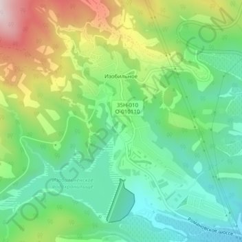
Name: Izobil'noe topographic map, elevation, terrain.
Average elevation: 235 m
Minimum elevation: 71 m
Maximum elevation: 539 m
Make a donation
Gear up for your next adventure:
As an Amazon Associate, this site earns from qualifying purchases at no extra cost to you.
Other topographic maps
Click on a map to view its topography, its elevation and its terrain.
Yalta
Ukraine > Autonomous Republic of Crimea > Ялтинський район > город Ялта
Average elevation: 214 m
Okhotnichye
Ukraine > Autonomous Republic of Crimea > Ялтинський район
Okhotnyche is the highest located settlement in Crimea, at an elevation of 1,160 metres (3,810 ft). The settlement is located on the Ai-Petri mountain 19 km (12 mi) southwest from Livadiya, which it is administratively subordinate to. Its population was 34 in the 2001 Ukrainian census. Current population: 17…
Average elevation: 939 m
Ai-Petri
Ukraine > Autonomous Republic of Crimea > Ялтинський район > Ливадийский поселковый совет
Average elevation: 819 m
Yalta
Ukraine > Autonomous Republic of Crimea > Ялтинський район > город Ялта
Average elevation: 214 m
Make a donation
Gear up for your next adventure:
As an Amazon Associate, this site earns from qualifying purchases at no extra cost to you.
Livadiya
Ukraine > Autonomous Republic of Crimea > Ялтинський район > Ливадийский поселковый совет
Average elevation: 172 m