Geolocate

Becetto topographic map

Click on the map to display elevation.

About this map

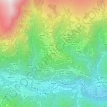
Name: Becetto topographic map, elevation, terrain.

Location: Becetto, Sampeyre, Cuneo, Piemonte, Italia (44.56884 7.18340 44.60884 7.22340)

Average elevation: 1,332 m

Minimum elevation: 826 m

Maximum elevation: 2,298 m

Other topographic maps

Click on a map to view its topography, its elevation and its terrain.

Lago di Luca

Italia > Piemonte > Cuneo > Sampeyre

Average elevation: 2,342 m

Gear up for your next adventure:

🥾Mountain Hiking Boots - High-traction boots for rocky terrain
🌬️Windproof Camp Stove - Efficient cooking even on exposed mountain peaks
🥾Light Trekking Boots - Supportive boots for multi-day treks
🎒Hiking Daypack - Lightweight and durable backpacks for day trips and excursions
🥾Hiking Shorts - Breathable shorts suitable for summer hikes

As an Amazon Associate, this site earns from qualifying purchases at no extra cost to you.