
Make a donation
Gear up for your next adventure:
As an Amazon Associate, this site earns from qualifying purchases at no extra cost to you.
Tautavel topographic map
Click on the map to display elevation.
Make a donation
Gear up for your next adventure:
As an Amazon Associate, this site earns from qualifying purchases at no extra cost to you.
Tautavel
La tour del Far est située au sud-est du village, sur la Serra de Talteüll, à une altitude de 485 m, à la fin du terme avec Cases-de-Pène. La Torre del Far est une tour de guet médiévale et une construction romane. Elle a été construite avant 1341. Elle a été inscrite au titre des monuments historiques en 1986. Elle est accessible par un sentier de randonnée.
Make a donation
Gear up for your next adventure:
As an Amazon Associate, this site earns from qualifying purchases at no extra cost to you.
About this map
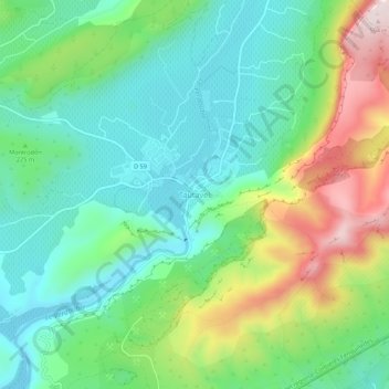
Name: Tautavel topographic map, elevation, terrain.
Average elevation: 221 m
Minimum elevation: 82 m
Maximum elevation: 518 m
Make a donation
Gear up for your next adventure:
As an Amazon Associate, this site earns from qualifying purchases at no extra cost to you.