Geolocate

Dane topographic map

Click on the map to display elevation.

About this map

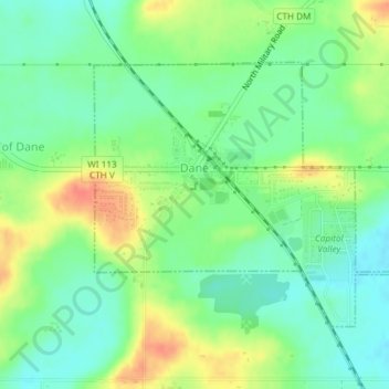
Name: Dane topographic map, elevation, terrain.

Location: Dane, Dane County, Wisconsin, United States (43.23953 -89.51109 43.25789 -89.48115)

Average elevation: 327 m

Minimum elevation: 308 m

Maximum elevation: 355 m

Gear up for your next adventure:

🗺️Topographic Maps - Detailed maps to explore trails, mountains, and wilderness areas
💧Hydration Bladder - Hands-free hydration solution for long treks
🥾Trail Running Shoes - Lightweight and durable shoes for trail running
🥾Waterproof Hiking Shoes - Durable shoes for wet and rugged trails
🎒Hiking Backpack - Lightweight and ergonomic backpacks for day hikes or multi-day treks

As an Amazon Associate, this site earns from qualifying purchases at no extra cost to you.