
Make a donation
Gear up for your next adventure:
As an Amazon Associate, this site earns from qualifying purchases at no extra cost to you.
South Bohemian Region topographic map
Click on the map to display elevation.
Make a donation
Gear up for your next adventure:
As an Amazon Associate, this site earns from qualifying purchases at no extra cost to you.
South Bohemian Region
The central part of the South Bohemian Region consists of the České Budějovice Basin and Třeboň Basin. The southwest consists of the Bohemian Forest mountain range and its foothills, the Gratzen Mountains and its foothills are located to the south. The northern part of the region extends to the Central Bohemian Uplands. The eastern part lies in the Bohemian-Moravian Highlands. The highest elevation in the region is the 1,378-metre (4,521 ft) high Plechý in the Bohemian Forest, the lowest elevation with 350 m (1,150 ft) above sea level is at the Orlík Dam.
Make a donation
Gear up for your next adventure:
As an Amazon Associate, this site earns from qualifying purchases at no extra cost to you.
About this map
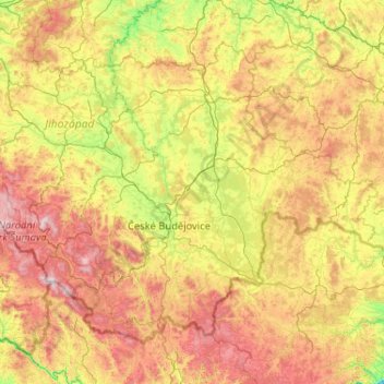
Name: South Bohemian Region topographic map, elevation, terrain.
Location: South Bohemian Region, Southwest, Czechia (48.55181 13.53597 49.62111 15.60420)
Average elevation: 576 m
Minimum elevation: 200 m
Maximum elevation: 1,365 m
Make a donation
Gear up for your next adventure:
As an Amazon Associate, this site earns from qualifying purchases at no extra cost to you.
Other topographic maps
Click on a map to view its topography, its elevation and its terrain.
Make a donation
Gear up for your next adventure:
As an Amazon Associate, this site earns from qualifying purchases at no extra cost to you.
Make a donation
Gear up for your next adventure:
As an Amazon Associate, this site earns from qualifying purchases at no extra cost to you.
Historic Centre of Český Krumlov
Czechia > Southwest > South Bohemian Region > Český Krumlov
Average elevation: 542 m
Make a donation
Gear up for your next adventure:
As an Amazon Associate, this site earns from qualifying purchases at no extra cost to you.