
Make a donation
Gear up for your next adventure:
As an Amazon Associate, this site earns from qualifying purchases at no extra cost to you.
Kirby Bellars topographic map
Click on the map to display elevation.
Make a donation
Gear up for your next adventure:
As an Amazon Associate, this site earns from qualifying purchases at no extra cost to you.
About this map
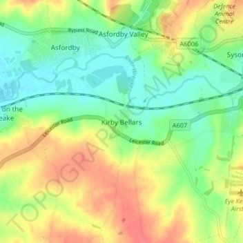
Name: Kirby Bellars topographic map, elevation, terrain.
Average elevation: 87 m
Minimum elevation: 63 m
Maximum elevation: 117 m
Make a donation
Gear up for your next adventure:
As an Amazon Associate, this site earns from qualifying purchases at no extra cost to you.
Other topographic maps
Click on a map to view its topography, its elevation and its terrain.
Bottesford
United Kingdom > England > Leicestershire > Melton
Bottesford's many listed buildings include the grade I listed 13th-century Church of St Mary the Virgin. There are two scheduled monuments within the village – Fleming's Bridge and the stone cross in the Market Place. The stocks and whipping post are Grade II listed. One of the Grade II listed buildings,…
Average elevation: 39 m