Geolocate

Pedregal topographic map

Click on the map to display elevation.

About this map

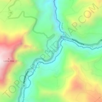
Name: Pedregal topographic map, elevation, terrain.

Location: Pedregal, Imués, La Sabana, Nariño, RAP Pacífico, Colombia (1.03047 -77.47329 1.07047 -77.43329)

Average elevation: 2,052 m

Minimum elevation: 1,607 m

Maximum elevation: 2,783 m

Gear up for your next adventure:

🧤Rechargeable Heated Gloves - Extreme warmth for Canadian winter expeditions
🧴Outdoor Sunscreen - High SPF protection for high-altitude UV exposure
🦶Hiking Shoe Insoles - Added support for high arches and long days on feet
🥾Trail Running Shoes - Lightweight and durable shoes for trail running
🍽️Titanium Camping Spork - Ultralight and indestructible eating utensil

As an Amazon Associate, this site earns from qualifying purchases at no extra cost to you.