
Make a donation
Gear up for your next adventure:
As an Amazon Associate, this site earns from qualifying purchases at no extra cost to you.
Winden topographic map
Click on the map to display elevation.
Make a donation
Gear up for your next adventure:
As an Amazon Associate, this site earns from qualifying purchases at no extra cost to you.
Winden
Winden ist uralter Siedlungsraum. Bodenfunde lassen auf eine keltoromanische Besiedlung schließen. Dabei muss es sich um den keltischen Stamm der Eburonen gehandelt haben. Auf der Anhöhe „Hochkoppel“, einem Höhenplateau nahe dem Windener Hemgenberg, befand sich zu dieser Zeit eine befestigte keltische Fliehburg, die dort um die Zeitenwende kurz vor der römischen Eroberung des Rheinlandes errichtet wurde.
Make a donation
Gear up for your next adventure:
As an Amazon Associate, this site earns from qualifying purchases at no extra cost to you.
About this map
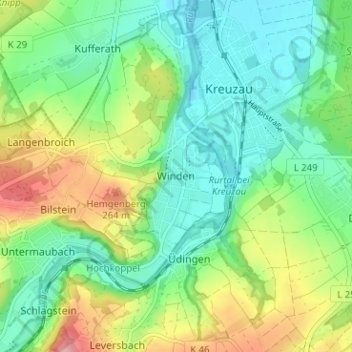
Name: Winden topographic map, elevation, terrain.
Average elevation: 186 m
Minimum elevation: 139 m
Maximum elevation: 281 m
Make a donation
Gear up for your next adventure:
As an Amazon Associate, this site earns from qualifying purchases at no extra cost to you.
Other topographic maps
Click on a map to view its topography, its elevation and its terrain.
Drover Heide
Deutschland > Nordrhein-Westfalen > Kreis Düren > Kreuzau > Stockheim
Average elevation: 184 m