Geolocate

Ansford topographic map

Click on the map to display elevation.

About this map

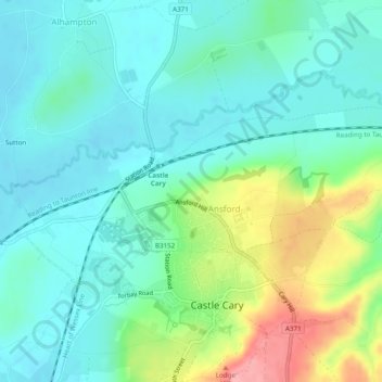
Name: Ansford topographic map, elevation, terrain.

Location: Ansford, Somerset, England, United Kingdom (51.08832 -2.54100 51.10742 -2.49244)

Average elevation: 67 m

Minimum elevation: 34 m

Maximum elevation: 156 m

Gear up for your next adventure:

🔭Outdoor Binoculars - Lightweight binoculars for birdwatching and hiking
🥾Waterproof Hiking Boots - Boots keeping your feet dry in wet conditions
💧Reusable Water Bottle - Durable water bottles for hydration on trails
🧼Travel Hand Sanitizer - Keep hands clean when water is scarce
👖Convertible Hiking Pants - Zip-off legs to adapt to changing weather conditions

As an Amazon Associate, this site earns from qualifying purchases at no extra cost to you.