
Make a donation
Gear up for your next adventure:
As an Amazon Associate, this site earns from qualifying purchases at no extra cost to you.
Freehold topographic map
Click on the map to display elevation.
Make a donation
Gear up for your next adventure:
As an Amazon Associate, this site earns from qualifying purchases at no extra cost to you.
Freehold
Freehold has an elevation of 174 feet (53 m) above sea level at its center.
Make a donation
Gear up for your next adventure:
As an Amazon Associate, this site earns from qualifying purchases at no extra cost to you.
About this map
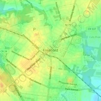
Name: Freehold topographic map, elevation, terrain.
Location: Freehold, Monmouth County, New Jersey, United States (40.24737 -74.29201 40.27253 -74.26161)
Average elevation: 53 m
Minimum elevation: 37 m
Maximum elevation: 64 m
Make a donation
Gear up for your next adventure:
As an Amazon Associate, this site earns from qualifying purchases at no extra cost to you.
Other topographic maps
Click on a map to view its topography, its elevation and its terrain.
Freneau Woods Park
United States > New Jersey > Monmouth County > Aberdeen Township > Henningers Mill
Average elevation: 23 m
Make a donation
Gear up for your next adventure:
As an Amazon Associate, this site earns from qualifying purchases at no extra cost to you.
Burlington Heights
United States > New Jersey > Monmouth County > Freehold Township
Average elevation: 47 m
Make a donation
Gear up for your next adventure:
As an Amazon Associate, this site earns from qualifying purchases at no extra cost to you.
Hendrickson Corners
United States > New Jersey > Monmouth County > Middletown Township
Average elevation: 22 m
Van Marters Corner
United States > New Jersey > Monmouth County > Hazlet Township
Average elevation: 6 m
Homes Mills
United States > New Jersey > Monmouth County > Upper Freehold Township
Average elevation: 34 m
Make a donation
Gear up for your next adventure:
As an Amazon Associate, this site earns from qualifying purchases at no extra cost to you.
Robinsville
United States > New Jersey > Monmouth County > Upper Freehold Township
Average elevation: 56 m
Make a donation
Gear up for your next adventure:
As an Amazon Associate, this site earns from qualifying purchases at no extra cost to you.
Make a donation
Gear up for your next adventure:
As an Amazon Associate, this site earns from qualifying purchases at no extra cost to you.
Make a donation
Gear up for your next adventure:
As an Amazon Associate, this site earns from qualifying purchases at no extra cost to you.
Emleys Hill
United States > New Jersey > Monmouth County > Upper Freehold Township
Average elevation: 46 m
Hendrickson Corners
United States > New Jersey > Monmouth County > Middletown Township
Average elevation: 22 m
Make a donation
Gear up for your next adventure:
As an Amazon Associate, this site earns from qualifying purchases at no extra cost to you.
Make a donation
Gear up for your next adventure:
As an Amazon Associate, this site earns from qualifying purchases at no extra cost to you.
Make a donation
Gear up for your next adventure:
As an Amazon Associate, this site earns from qualifying purchases at no extra cost to you.
Hendrickson Corners
United States > New Jersey > Monmouth County > Middletown Township
Average elevation: 22 m
Make a donation
Gear up for your next adventure:
As an Amazon Associate, this site earns from qualifying purchases at no extra cost to you.
New Monmouth
United States > New Jersey > Monmouth County > Middletown Township
Average elevation: 15 m
Bradley Park
United States > New Jersey > Monmouth County > Neptune > Bradley Park
Average elevation: 7 m
Make a donation
Gear up for your next adventure:
As an Amazon Associate, this site earns from qualifying purchases at no extra cost to you.
Port-au-Peck
United States > New Jersey > Monmouth County > Oceanport > Port-au-Peck
Average elevation: 4 m
Freehold
United States > New Jersey > Monmouth County > Freehold Borough > Freehold
Freehold has an elevation of 174 feet (53 m) above sea level at its center.
Average elevation: 45 m
Make a donation
Gear up for your next adventure:
As an Amazon Associate, this site earns from qualifying purchases at no extra cost to you.
Collingwood Park
United States > New Jersey > Monmouth County > Collingwood Park
Average elevation: 31 m
Carrs Tavern
United States > New Jersey > Monmouth County > Millstone Township > Carrs Tavern
Average elevation: 53 m
Make a donation
Gear up for your next adventure:
As an Amazon Associate, this site earns from qualifying purchases at no extra cost to you.