Geolocate

Boone topographic map

Click on the map to display elevation.

About this map

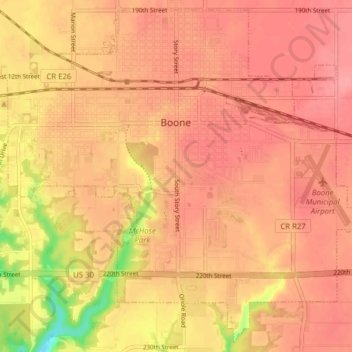
Name: Boone topographic map, elevation, terrain.

Location: Boone, Boone County, Iowa, 50036, United States (42.02338 -93.91764 42.07826 -93.83969)

Average elevation: 339 m

Minimum elevation: 277 m

Maximum elevation: 361 m

Other topographic maps

Click on a map to view its topography, its elevation and its terrain.

Centerville

United States > Iowa > Boone County

Average elevation: 314 m

Fraser

United States > Iowa > Boone County > Fraser > Fraser

Average elevation: 317 m

Gear up for your next adventure:

🔋Emergency Crank Radio - Weather alerts and power without needing batteries
🧼Biodegradable Camp Soap - Environmentally friendly cleaning for gear and body
💧Collapsible Water Bottle - Space-saving water bottle for outdoor activities
🦶Anti-Blister Balm - Prevents friction and hotspots during long ascents
🥾Waterproof Hiking Boots - Essential footwear for rugged terrain and wet Canadian trails

As an Amazon Associate, this site earns from qualifying purchases at no extra cost to you.