
Thank you for supporting this site ❤️
Make a donation
Make a donation
Gear up for your next adventure:
As an Amazon Associate, this site earns from qualifying purchases at no extra cost to you.
Tobera topographic map
Click on the map to display elevation.
Thank you for supporting this site ❤️
Make a donation
Make a donation
Gear up for your next adventure:
As an Amazon Associate, this site earns from qualifying purchases at no extra cost to you.
About this map
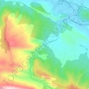
Name: Tobera topographic map, elevation, terrain.
Location: Tobera, Frías, Burgos, Castela e Leão, 09211, Espanha (42.72990 -3.32550 42.76990 -3.28550)
Average elevation: 695 m
Minimum elevation: 517 m
Maximum elevation: 1,037 m
Thank you for supporting this site ❤️
Make a donation
Make a donation
Gear up for your next adventure:
As an Amazon Associate, this site earns from qualifying purchases at no extra cost to you.