
Thank you for supporting this site ❤️
Make a donation
Make a donation
Gear up for your next adventure:
As an Amazon Associate, this site earns from qualifying purchases at no extra cost to you.
Jima topographic map
Click on the map to display elevation.
Thank you for supporting this site ❤️
Make a donation
Make a donation
Gear up for your next adventure:
As an Amazon Associate, this site earns from qualifying purchases at no extra cost to you.
About this map
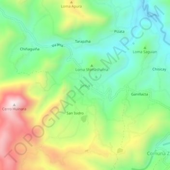
Name: Jima topographic map, elevation, terrain.
Location: Jima, San Miguel de Jima, Sigsig, Azuay, Ecuador (-3.21106 -78.97780 -3.17106 -78.93780)
Average elevation: 2,890 m
Minimum elevation: 2,625 m
Maximum elevation: 3,331 m
Thank you for supporting this site ❤️
Make a donation
Make a donation
Gear up for your next adventure:
As an Amazon Associate, this site earns from qualifying purchases at no extra cost to you.