Geolocate

Vaddem topographic map

Click on the map to display elevation.

About this map

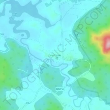
Name: Vaddem topographic map, elevation, terrain.

Location: Vaddem, Sanguem, South Goa, Goa, India (15.09706 74.18572 15.13706 74.22572)

Average elevation: 69 m

Minimum elevation: 35 m

Maximum elevation: 293 m

Other topographic maps

Click on a map to view its topography, its elevation and its terrain.

Salaulim Dam

India > Goa > Sanguem > Sanguem

Average elevation: 39 m

Maulinguem

India > Goa > Sanguem

Average elevation: 101 m

Sanvordem

India > Goa > Sanguem

Average elevation: 28 m

Gear up for your next adventure:

🥾Hiking Shoes - Durable and comfortable shoes for trail hiking
🦯Trekking Poles - Reduced impact on joints for steep topographic climbs
🎒Hiking Backpack - Lightweight and ergonomic backpacks for day hikes or multi-day treks
🥾Mountain Hiking Boots - High-traction boots for rocky terrain
🧢Hiking Hat - Sun-protective and breathable hats for long treks

As an Amazon Associate, this site earns from qualifying purchases at no extra cost to you.