Geolocate

Vizcable topographic map

Click on the map to display elevation.

About this map

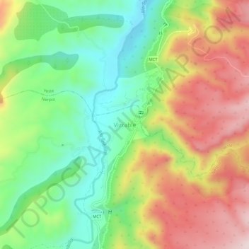
Name: Vizcable topographic map, elevation, terrain.

Location: Vizcable, Albacete, Castilla-La Mancha, España (38.24909 -2.28082 38.28909 -2.24082)

Average elevation: 886 m

Minimum elevation: 695 m

Maximum elevation: 1,127 m

Gear up for your next adventure:

🔦LED Headtorch - Bright and durable light for night activities
🔪Outdoor Multitool - Versatile tool for repairs and food prep in the wild
🥾Approach Boots - Comfortable boots for hiking and climbing approaches
🥘Camping Cookware Set - Compact nesting pots and pans for trail cooking
🧴First Aid Kit - Essential first aid supplies for outdoor emergencies

As an Amazon Associate, this site earns from qualifying purchases at no extra cost to you.