Geolocate

Capracotta topographic map

Click on the map to display elevation.

About this map

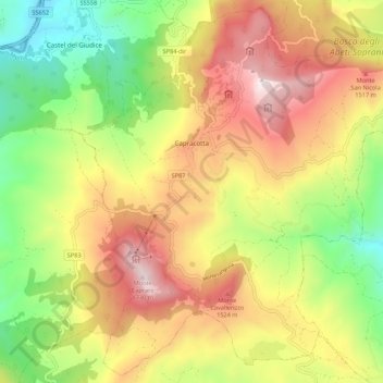
Name: Capracotta topographic map, elevation, terrain.

Location: Capracotta, Isernia, Molise, 86082, Italy (41.78479 14.23321 41.86253 14.34163)

Average elevation: 1,196 m

Minimum elevation: 705 m

Maximum elevation: 1,733 m

Gear up for your next adventure:

🔨Vehicle Emergency Tool - Safety tool for remote road trips to trailheads
🔥Emergency Fire Starter - Reliable ignition source for all weather conditions
🔦UV Flashlight - Detect minerals or specific insects in the dark
🧢Outdoor Cap - Protective cap for sun and rain during hikes
🧦Hiking Liner Socks - Thin base layer to prevent friction and blisters

As an Amazon Associate, this site earns from qualifying purchases at no extra cost to you.