
Make a donation
Gear up for your next adventure:
As an Amazon Associate, this site earns from qualifying purchases at no extra cost to you.
Térmens topographic map
Click on the map to display elevation.
Make a donation
Gear up for your next adventure:
As an Amazon Associate, this site earns from qualifying purchases at no extra cost to you.
Térmens
Térmens liegt etwa 22 Kilometer nordöstlich von Lleida und östlich des Flusses Segre in einer Höhe von ca. 210 m.
Make a donation
Gear up for your next adventure:
As an Amazon Associate, this site earns from qualifying purchases at no extra cost to you.
About this map
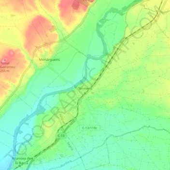
Name: Térmens topographic map, elevation, terrain.
Location: Térmens, Noguera, Lleida, Katalonien, 25670, Spanien (41.68572 0.74203 41.75388 0.83141)
Average elevation: 207 m
Minimum elevation: 173 m
Maximum elevation: 264 m
Make a donation
Gear up for your next adventure:
As an Amazon Associate, this site earns from qualifying purchases at no extra cost to you.
Other topographic maps
Click on a map to view its topography, its elevation and its terrain.