Geolocate

Afton topographic map

Click on the map to display elevation.

About this map

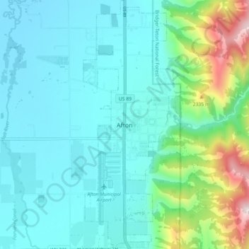
Name: Afton topographic map, elevation, terrain.

Location: Afton, Lincoln County, Wyoming, 83110, United States (42.69280 -110.94824 42.75800 -110.91349)

Average elevation: 2,001 m

Minimum elevation: 1,847 m

Maximum elevation: 2,676 m

Other topographic maps

Click on a map to view its topography, its elevation and its terrain.

Freedom

United States > Wyoming > Lincoln County

Average elevation: 1,774 m

Salt River Range

United States > Wyoming > Lincoln County

Average elevation: 2,404 m

Wyoming Peak

United States > Wyoming > Lincoln County

Average elevation: 3,108 m

Wyoming Range

United States > Wyoming > Lincoln County

Average elevation: 2,357 m

Gear up for your next adventure:

💧Filtered Water Bottle - Safe drinking water on the go
🧥Thermal Fleece Jacket - Versatile insulation for changing mountain temperatures
🥾Approach Boots - Comfortable boots for hiking and climbing approaches
🧢Hiking Hat - Sun-protective and breathable hats for long treks
🛶Waterproof Dry Bags - Keep electronics and clothes dry during river crossings

As an Amazon Associate, this site earns from qualifying purchases at no extra cost to you.