Geolocate

Frövi topographic map

Click on the map to display elevation.

About this map

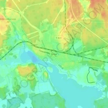
Name: Frövi topographic map, elevation, terrain.

Location: Frövi, Lindesbergs kommun, Örebro County, 718 92, Sweden (59.44620 15.34507 59.48620 15.38507)

Average elevation: 43 m

Minimum elevation: 29 m

Maximum elevation: 63 m

Other topographic maps

Click on a map to view its topography, its elevation and its terrain.

Lindesbergs kommun

Sweden > Örebro County

Average elevation: 151 m

Gear up for your next adventure:

🥾Hiking Shorts - Breathable shorts suitable for summer hikes
🥾Trail Hiking Shoes - Durable shoes designed for rugged trails
💧Collapsible Water Bottle - Space-saving water bottle for outdoor activities
🛶Waterproof Dry Bags - Keep electronics and clothes dry during river crossings
🩹Compact First Aid Kit - Pre-packed essentials for common trail injuries

As an Amazon Associate, this site earns from qualifying purchases at no extra cost to you.