
Make a donation
Gear up for your next adventure:
As an Amazon Associate, this site earns from qualifying purchases at no extra cost to you.
Chakdaha topographic map
Click on the map to display elevation.
Make a donation
Gear up for your next adventure:
As an Amazon Associate, this site earns from qualifying purchases at no extra cost to you.
Chakdaha
Chakdaha is a prominent urban local body in the district of Nadia, one of the southern districts of West Bengal. Chakdaha's location is 23°05′N 88°31′E / 23.08°N 88.52°E / 23.08; 88.52. It has an average elevation of 11 meters (36 feet) and is 62 km north of the state capital, Kolkata. It is on National Highway 12 (old number NH 34), an approximate 2-hour drive from Kolkata via the National Highway NH12. Regular public transport operates from Madhyamgram (near Kolkata) to Chakdaha, with low-cost buses running every 20 minutes during the day time.
Make a donation
Gear up for your next adventure:
As an Amazon Associate, this site earns from qualifying purchases at no extra cost to you.
About this map
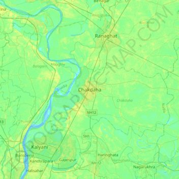
Name: Chakdaha topographic map, elevation, terrain.
Location: Chakdaha, Nadia, West Bengal, 741222, India (22.91750 88.37204 23.23750 88.69204)
Average elevation: 10 m
Minimum elevation: -3 m
Maximum elevation: 30 m
Make a donation
Gear up for your next adventure:
As an Amazon Associate, this site earns from qualifying purchases at no extra cost to you.
Other topographic maps
Click on a map to view its topography, its elevation and its terrain.