
Make a donation
Gear up for your next adventure:
As an Amazon Associate, this site earns from qualifying purchases at no extra cost to you.
Valwig topographic map
Click on the map to display elevation.
Make a donation
Gear up for your next adventure:
As an Amazon Associate, this site earns from qualifying purchases at no extra cost to you.
Valwig
Die Gemeinde Valwig gliedert sich in die folgenden Ortsteile (mit Höhenangaben).
Make a donation
Gear up for your next adventure:
As an Amazon Associate, this site earns from qualifying purchases at no extra cost to you.
About this map
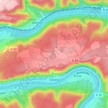
Name: Valwig topographic map, elevation, terrain.
Average elevation: 208 m
Minimum elevation: 73 m
Maximum elevation: 345 m
Make a donation
Gear up for your next adventure:
As an Amazon Associate, this site earns from qualifying purchases at no extra cost to you.
Other topographic maps
Click on a map to view its topography, its elevation and its terrain.
Löffelscheid
Deutschland > Rheinland-Pfalz > Landkreis Cochem-Zell
Die festliche Einweihung der neuen Filialkirche in Löffelscheid „Maria Heimsuchung“ fand am 5. Juli 1964 statt. Patronin ist die Mutter Gottes („Maria Heimsuchung“), zweiter Patron ist der Heilige Nikolaus. Die Kirche ist ein Rundbau (zwei Kegel wurden ineinandergeschoben). Der Architekt war Bruno…
Average elevation: 439 m
Müdener Bock
Deutschland > Rheinland-Pfalz > Landkreis Cochem-Zell > Müden (Mosel)
Average elevation: 244 m
Make a donation
Gear up for your next adventure:
As an Amazon Associate, this site earns from qualifying purchases at no extra cost to you.
Make a donation
Gear up for your next adventure:
As an Amazon Associate, this site earns from qualifying purchases at no extra cost to you.