Geolocate

Milton topographic map

Click on the map to display elevation.

About this map

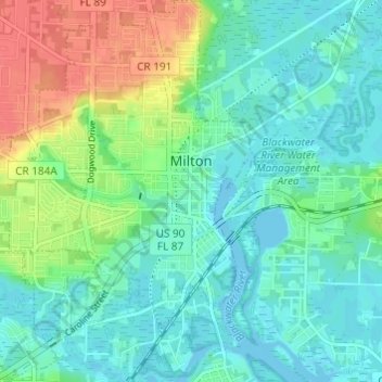
Name: Milton topographic map, elevation, terrain.

Location: Milton, Santa Rosa County, Florida, United States (30.60225 -87.07743 30.65440 -87.02938)

Average elevation: 15 m

Minimum elevation: -3 m

Maximum elevation: 51 m

Other topographic maps

Click on a map to view its topography, its elevation and its terrain.

Navarre

United States > Florida > Santa Rosa County

Navarre is located at 30°24′04″N 86°51′47″W / 30.401°N 86.863°W / 30.401; -86.863Coordinates: 30°24′04″N 86°51′47″W / 30.401°N 86.863°W / 30.401; -86.863. It is located within a portion of the Florida Panhandle observing the Central Time Zone. Elevation is at an average of 10 feet (3.0 m).

Average elevation: 4 m

Munson

United States > Florida > Santa Rosa County

Average elevation: 50 m

Bagdad

United States > Florida > Santa Rosa County

Average elevation: 10 m

Navarre

United States > Florida > Santa Rosa County

Navarre is located at 30°24′04″N 86°51′47″W / 30.401°N 86.863°W / 30.401; -86.863Coordinates: 30°24′04″N 86°51′47″W / 30.401°N 86.863°W / 30.401; -86.863. It is located within a portion of the Florida Panhandle observing the Central Time Zone. Elevation is at an average of 10 feet (3.0 m).

Average elevation: 4 m

Chumuckla

United States > Florida > Santa Rosa County

Average elevation: 49 m

Allentown

United States > Florida > Santa Rosa County

Average elevation: 58 m

Gear up for your next adventure:

🧥Ultralight Puffy Jacket - Maximum warmth that packs down to the size of an orange
🧰Multitool Knife - Compact and versatile tool for outdoor use
🧦Hiking Socks - Moisture-wicking and comfortable socks for long hikes
🧼Biodegradable Camp Soap - Environmentally friendly cleaning for gear and body
🎒Hiking Backpack - Lightweight and ergonomic backpacks for day hikes or multi-day treks

As an Amazon Associate, this site earns from qualifying purchases at no extra cost to you.