
Make a donation
Gear up for your next adventure:
As an Amazon Associate, this site earns from qualifying purchases at no extra cost to you.
Каона topographic map
Click on the map to display elevation.
Make a donation
Gear up for your next adventure:
As an Amazon Associate, this site earns from qualifying purchases at no extra cost to you.
About this map
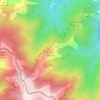
Name: Каона topographic map, elevation, terrain.
Average elevation: 1,322 m
Minimum elevation: 1,005 m
Maximum elevation: 1,633 m
Make a donation
Gear up for your next adventure:
As an Amazon Associate, this site earns from qualifying purchases at no extra cost to you.
Other topographic maps
Click on a map to view its topography, its elevation and its terrain.
Kursumlijska Banja
Serbia > Toplica Administrative District > Kursumlija Municipality
It is located in the valley of the river Banjska, right tributary to the Toplica river. It spreads on the valley slopes of the Banjska, and on the southeast slopes of the Kopaonik mountain. It developed between the altitudes of 440 to 500 m (1,440 to 1,640 ft).
Average elevation: 626 m