
Thank you for supporting this site ❤️
Make a donation
Make a donation
Gear up for your next adventure:
As an Amazon Associate, this site earns from qualifying purchases at no extra cost to you.
Nirsa topographic map
Click on the map to display elevation.
Thank you for supporting this site ❤️
Make a donation
Make a donation
Gear up for your next adventure:
As an Amazon Associate, this site earns from qualifying purchases at no extra cost to you.
Nirsa
Nirsa is located at 23°47′N 86°43′E / 23.78°N 86.72°E / 23.78; 86.72.[1] It has an average elevation of 139 metres (456 ft).
Thank you for supporting this site ❤️
Make a donation
Make a donation
Gear up for your next adventure:
As an Amazon Associate, this site earns from qualifying purchases at no extra cost to you.
About this map
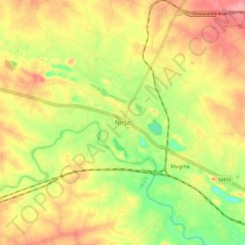
Name: Nirsa topographic map, elevation, terrain.
Location: Nirsa, Nirsa-Cum-Chirkunda, Dhanbad, Jharkhand, India (23.74444 86.66685 23.82444 86.74685)
Average elevation: 148 m
Minimum elevation: 94 m
Maximum elevation: 192 m
Thank you for supporting this site ❤️
Make a donation
Make a donation
Gear up for your next adventure:
As an Amazon Associate, this site earns from qualifying purchases at no extra cost to you.